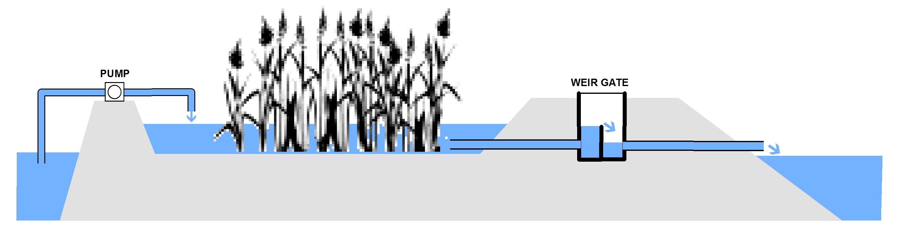
We’ve determined that our research and management efforts at Point au Sable are enhanced if we’re able to manipulate the lagoon water level. This is accomplished by pumping Bay water into the lagoon when the level drops below our target. Excess water can be released back to the Bay via a weir gate when conditions warrant. The above diagram shows the general concept. An online map illustrates the physical arrangement of the various project components.
Water Level Control Structures
 Containment Berms – The lagoon is almost completely surrounded by terrain high enough to contain water up to the level required by the project. In fall of 2013, an excavation contractor was hired to construct berms at two locations where the natural terrain dipped below what was needed for full containment.
Weir Gate – A weir gate was incorporated into one of the berms to permit excess water to be drained from the lagoon. The top rim elevation of the gate’s access hatch was measured as part of the surveying work done in June of 2014. Having the absolute elevation of the weir gate assembly allows us to calculate the invert elevation – an important parameter for analyzing lagoon water levels.
Water Level Measurement
We’re using simple staff gauges for recording water levels. Normally one gauge would be enough, but we’re collecting data at several locations around the lagoon. There are a couple of reasons. First, there are several gauges that are holdovers from earlier data collection and we intend to incorporate that information into the current study. However the “zero” reading on these older gauges is above the point that the lagoon water level can drop down to in summer – additional gauges were deployed where the lagoon is deeper to permit data collection during periods of low water. Second, it appears that the east and west ends of the lagoon are physically separated by terrain features during periods of low water. Having gauges at both ends of the lagoon will allow us to figure out if if there is a hydrologic separation as well.
 Staff gauge SG12-EAST – the gauge is one of three deployed in 2012. It consists of a wooden board attached to a steel fence post as shown at right. It’s located in a fairly shallow part of the lagoon so its limited to recording levels > 579 feet. We intend to go back and roll earlier data from SG12-EAST into the current project and we will continue to take readings there as long as it seems productive to do so.
 Staff gauge SG12-WEST – the gauge is one of three deployed in 2012. It consists of a wooden board attached to a steel fence post as shown at right. It’s located in a fairly shallow part of the lagoon so it is limited to recording levels > 579 feet. We intend to go back and roll earlier data from SG12-WEST into the current project and we will continue to take readings there as long as it seems productive to do so.
 Staff gauge SG12-RET – the gauge is one of three deployed in 2012. It consists of a wooden board attached to a steel fence post as shown at right. It’s located in a fairly shallow part of the lagoon so its limited to recording levels > 579 feet. The scale markings on the gauge use an unusual format that makes it difficult to use earlier data from SG12-RET in the current project. We’re hoping to be able to retire this gauge before too long. In the meantime we will continue to take readings there.

 Staff gauge SG14-01 – the gauge is one of several new instruments deployed in 2014. It’s fabricated from fiberglass and uses standard scale markings as shown at right. It’s located in a ponded area just upstream of the weir gate.
Staff gauge SG14-02 – the gauge is one of several new instruments deployed in 2014. It’s fabricated from fiberglass and uses standard scale markings. It’s located in a fairly deep part of the lagoon to permit recording of water levels as low as 576′.
Calibration – Water level measurements need to be referenced to absolute elevations. When a gauge is deployed, measurements are taken to tie its printed scale to a vertical datum, in our case NAVD88. Staff gauges are vulnerable to vandalism and environmental conditions so their vertical referencing should be checked at the beginning of each field season. The Staff Gauge Calibration Table shows the calibration history for the instruments used on this project.
Pump
COMING SOON