Over the years, research work at Point au Sable has been hampered by the lack of an accurate elevation reference. In June of 2014 a professional surveying firm was hired to establish reference elevations at the site. Survey-grade GPS methods were employed that achieve a vertical accuracy better than plus/minus .10 ft. Since most source data regarding land and water elevations is developed and published in feet, we use feet for our own measurements and in all our calculations. Where water levels are displayed in tables and reports, they are given first in feet followed by the International equivalent in parentheses. Absolute elevations are referenced to the North American Vertical Datum of 1988 (NAVD88).
Vertical Benchmarks
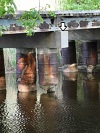
 Benchmark BM14-BRIDGE (584.83′) – the benchmark is located on the top surface of one of the concrete beams supporting the bridge over Wequiock Creek. It’s at the south end of the middle bridge support as shown at right. As of June 30, 2014 the benchmark is identified by a spot of pink paint. We’ll eventually install some kind of permanent marker.
 Benchmark BM12-LAGOONWEST – the reference elevation is the top of a steel post. The origin of the post is fuzzy. It was in a handy location and so was recruited as a vertical reference for some water level monitoring that was done in 2012.
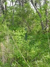
Benchmark BM14-LAGOONWEST (580.33′) – the reference elevation is the top of a 1″ steel pipe. The benchmark was installed in June of 2014 as part of a project to establish vertical control for the Point au Sable Water Level Project. The pipe is driven nearly flush with the ground and is about one foot south of BM12-WEST described above.
Weir Gate Rim (582.72′) – the reference elevation is the top of the weir gate structure (with cover removed).